
Geographic information systems (GIS) and geospatial technologies (GT) have moved into math and science courses at multiple levels, and teachers are learning how to integrate these tools into curriculums. Helping them is Janey Camp, research assistant professor of civil and environmental engineering at Vanderbilt University. Camp has received funding from Metro Nashville Public Schools (MNPS) to implement a pilot project to provide GIS training to teachers at Stratford, Glencliff and Hillsboro high schools.
The use of geospatial technologies, especially GIS and global positioning systems (GPS), are important tools that help educators, students, and their institutions answer personal and community questions with local to global implications. Educational use of these tools often begins in geography lessons but has extended into other subjects with an ever‐growing assortment of online resources, publications, and professional development opportunities for teachers.
“In today’s push for project-based learning and improved technological skill sets among high school graduates, geospatial technologies can be utilized to help accomplish both,” Principal Investigator Janey Camp said. “Students are exposed to a new way to think about data and information. Through learning how to draw relationships in the geospatial context, they learn to use software that is  currently being applied to many different fields including engineering, earth and social sciences, emergency management, and others.”
The year-long pilot project will measure the extent to which geospatial technology (specifically GIS mapping) can improve student performance in such diverse areas as reading, math and science. The program includes one week GT training for teachers with a focus on how to incorporate GIS into the high school curriculums.
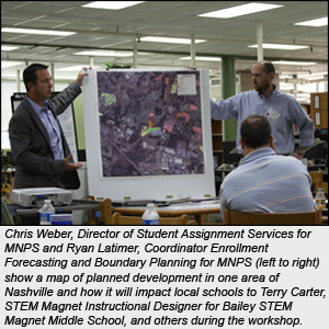
Local educators were trained August 1-5 at Stratford High School and speakers representing professionals that use GIS included Jeremy Weber, State Comptroller’s Office (Office of State and Local Government); Rich Cochran, GIS coordinator for the Tennessee Department of Environment and Conservation’s Division of Water Pollution Control; Zach Layne, Tennessee’s ESRI representative; Chris Weber, MNPS Director of Student Assignment Services; and Ryan Latimer, MNPS Coordinator Enrollment Forecasting and Boundary Planning.

During the school year, Camp and co-facilitator assistant professor of science education, University of North Carolina-Pembroke Rita Hagevik will serve as mentors to the teachers. Three day long follow-up workshops will be held throughout the year to further improve teacher’s geospatial technologies skill set and troubleshoot any difficulties in integrating GIS and GPS in their classrooms.
“This year’s pilot project is focused on developing curriculum for teachers and mentoring them throughout the school year. If we see positive response to use of the technology in the classroom, then it provides the ground work for trials in other schools as we further refine the curriculum and develop new ideas for classroom projects,”Camp said.
The program will measure the success of the project through student and teacher surveys along with student performance evaluations such as test scores. A successful pilot project could mean the inclusion of GIS instruction in more high schools and possibly in middle schools.
Beyond the classroom, GIS is currently being used in nearly every industry, both public and private sector. In 2004, the U.S. President identified geospatial technologies as one of the top three emerging fields, following biotechnology and nanotechnology. This implies that the integration of GIS into the classroom has both short and long‐term benefits. Students benefit in the short‐term from an enhanced learning environment and in the long‐term from acquiring skills required to compete in the global marketplace.